Flying a drone can be exciting, but before you send it high into the sky, it is important to understand the legal limits. One of the most common questions new and experienced pilots ask is how high a drone legally fly and what rules apply in different places. The answer depends on where you are flying, what kind of drone you use, and whether you are operating for recreational or commercial purposes. In most countries, drone altitude limits are regulated to reduce risks to airplanes, helicopters, people on the ground, and property. Knowing these rules helps you fly safely and avoid fines, warnings, or more serious penalties.
For beginners who are still learning the basics, our Beginner Drone Guide: 7 Smart Tips for Success can help you build safe habits before your first flight.
Table of Contents
Why Drone Altitude Limits Exist
Altitude limits are not just bureaucratic restrictions. They are designed to protect airspace users and the public. The higher a drone flies, the more likely it is to interfere with manned aircraft, especially near airports, heliports, and emergency flight paths. Even a small drone can cause serious damage if it collides with an airplane or helicopter.
There are also practical reasons for limiting height. As drones climb higher, they become harder to see and control. Signal interference, battery limitations, and weather conditions can all become more challenging at altitude. By setting a maximum legal flight height, regulators reduce the chances of accidents and make it easier for pilots to maintain safe control. That is why drone altitude limits matter even when a flight seems harmless.
Another important reason is accountability. If a pilot stays within drone altitude limits, it is easier to prove they were following the law if a question ever comes up after a flight. That can matter during an insurance claim, a safety review, or a routine inspection. It also helps new pilots build disciplined habits early, which makes every future flight more predictable.
Typical Legal Drone Flight Heights
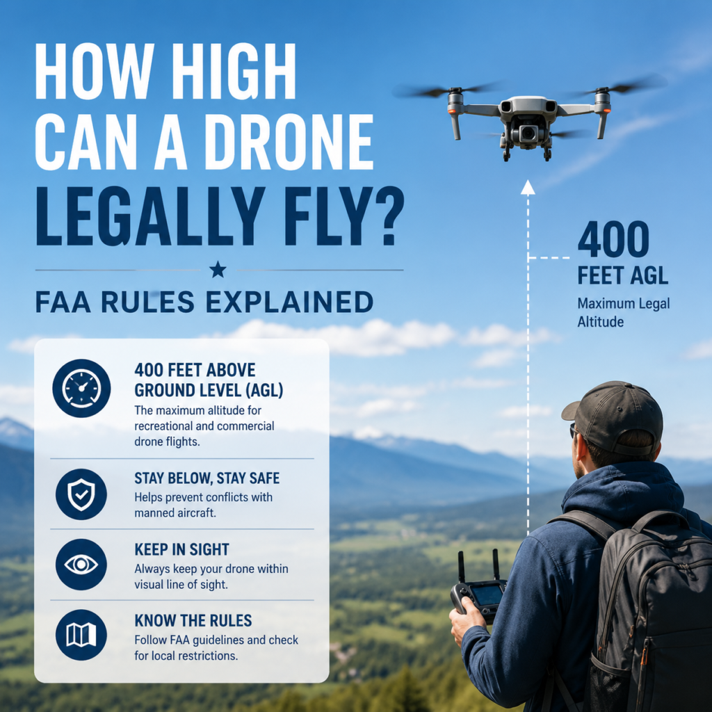
In many places, the standard legal ceiling for recreational drones is around 400 feet above ground level, or about 120 meters. This is one of the most widely recognized altitude limits in drone regulations. It is often used as a general rule to keep drones below the typical flight paths of low-flying aircraft.
That said, the number is not universal. Some countries use a similar cap but define it differently, while others may set extra conditions depending on the location or type of drone operation. If you are traveling with your aircraft, it is smart to verify the local drone altitude limits before you pack the batteries and take off.
United States
In the United States, the Federal Aviation Administration (FAA) generally allows recreational drone pilots to fly below 400 feet above ground level. For commercial operators flying under Part 107, the same 400-foot limit usually applies, with some exceptions when flying near structures. A drone can sometimes fly higher if it remains within a specific distance of a taller structure, but operators still need to follow all other airspace rules.
The FAA also expects pilots to understand airspace awareness, line of sight, and remote pilot responsibilities. Those details matter because drone altitude limits are only one part of legal operation. A flight that stays under 400 feet can still be illegal if it enters controlled airspace without authorization or creates a hazard for other aircraft.
To understand the official standard in more detail, review the FAA’s drone guidance on getting started with small unmanned aircraft.
United Kingdom
In the UK, the Civil Aviation Authority (CAA) generally limits drone flights to 400 feet above the surface. Pilots must also follow rules related to distance from people, buildings, and controlled airspace. Depending on the drone category and the type of operation, some flights may have additional restrictions.
If you are flying in a city or near sensitive sites, the practical ceiling may be lower than the general rule suggests. In those situations, drone altitude limits can be affected by local airspace design, nearby airports, and temporary restrictions tied to events or emergencies.
European Union
Across the European Union, drone rules are harmonized under EASA regulations. In the open category, the usual maximum altitude is 120 meters above ground level. Some operations may qualify for specific authorizations, but for most everyday flights, this is the standard limit.
Because the open category is designed for lower-risk operations, pilots are expected to stay well within the published ceiling and avoid unnecessary height gains. Even if a drone has enough battery to climb higher, the legal drone altitude limits remain the same unless you have a formal approval that says otherwise.
Other Countries
Many countries use a similar height restriction, though local laws can vary. Some regions may allow different limits in rural areas, require permission for higher flights, or impose stricter controls near sensitive locations. Always check the aviation authority in the country where you intend to fly rather than relying on general global assumptions. Even where the number is similar, drone altitude limits can still change by location or flight type.
If you are buying equipment for travel or mixed-use flying, our Drone Worth Buying? Honest Pros and Cons article can help you compare options with safety and practicality in mind.
What Counts as “Above Ground Level”?
The phrase “above ground level” is important because it means the drone’s altitude is measured relative to the terrain directly below it, not from sea level. This matters in hilly or mountainous areas. For example, a drone could be 400 feet above the ground and still be much higher relative to sea level if the area is elevated.
This distinction can create confusion. If you are flying near a slope, cliff, or valley, the legal altitude may change depending on the terrain beneath the drone. Because of that, many drone apps and flight planning tools use maps and altitude references to help pilots stay within the legal limit. When in doubt, remember that drone altitude limits are usually tied to the surface below the aircraft, not the number shown on a map label.
It is also useful to think in terms of the flight path, not just the starting point. A drone may take off from level ground, then pass over higher terrain or a building that changes the real separation between the aircraft and the surface. Good planning keeps the aircraft within drone altitude limits even when the ground rises or falls unexpectedly.
Exceptions and Special Permissions
Not every flight is limited to the standard recreational ceiling. In some situations, pilots may be allowed to fly higher with proper approval. These exceptions usually involve trained operators, special airspace clearance, or professional work such as inspections, surveying, or emergency operations. Even then, drone altitude limits still matter because the approval usually comes with conditions.
Flying Near Tall Structures
Some regulations allow drones to fly higher when operating close to a structure such as a tower, building, or mast. This is often used for inspection work. However, the drone must stay within a certain horizontal distance of the structure, and the pilot still needs to remain aware of nearby airspace restrictions.
This exception exists because a controlled inspection flight can be safer than trying to force a drone to stay artificially low around a tall object. Still, it is not a free pass. The operator must understand the exact terms of the allowance, because the structure-related rule does not override every other requirement.
Special Waivers or Authorizations
Commercial operators may apply for waivers or exemptions that permit higher flights. These requests are typically reviewed carefully and require a strong safety case. Approval is not automatic, and pilots must demonstrate that they can operate safely at the proposed altitude.
These approvals often come with added responsibilities such as recordkeeping, preflight checks, spotter use, or route planning. If you rely on an authorization, read every condition carefully and make sure your team understands it. Drone altitude limits may be modified by permission, but the obligations usually become stricter, not looser.
Emergency and Government Operations
Public safety agencies, search and rescue teams, and other authorized organizations may operate under different rules. These flights often take priority during emergencies and may involve coordination with air traffic control or other authorities.
Even in these cases, the goal is still safety. Higher operating heights can improve visibility, mapping, and situational awareness, but they must be balanced against other aircraft and mission risks. Emergency operators still use flight planning, communications, and altitude management to reduce danger.
Airspace Matters More Than Height Alone
A drone’s legal altitude is only one part of the picture. You also need to know whether the airspace itself allows drone flight. In some areas, even a low-altitude flight may be illegal without permission. Airports, military bases, prisons, and critical infrastructure sites often have no-fly zones or restricted zones.
That means the same drone can be legal in one neighborhood and restricted just a few miles away. The altitude number does not automatically make a flight lawful. To stay compliant, you must consider both the height of the aircraft and the type of airspace above the area where you plan to fly.
Controlled Airspace
Controlled airspace is managed by air traffic authorities to protect aircraft operations. Drone flights in these areas may require authorization, even if you are staying below the usual maximum altitude. Many countries use digital systems or apps to help pilots check restrictions before taking off.
If you are flying near a runway corridor or under a busy flight path, the risk is not theoretical. Manned aircraft may be descending, climbing, or conducting low-altitude approaches, and a drone can become a hazard very quickly. That is why drone altitude limits should always be checked alongside airspace charts or mobile flight tools.
Local Restrictions
Cities, event venues, national parks, and private properties may have additional rules or access limitations. While aviation authorities usually control the legal altitude, local rules can affect where and how you fly. It is always smart to confirm both national aviation rules and any site-specific restrictions.
For photographers and hobbyists comparing capabilities before a flight, our 4K Drone Buying Guide: 7 Smart Features can help you choose equipment that suits your planned use.
Planning a Legal Flight Step by Step
A good preflight routine makes drone altitude limits easier to follow. Start by checking the official aviation guidance for your country, then open a trusted map or flight app and confirm there are no temporary restrictions in the area. If the location is unfamiliar, zoom in and check nearby roads, towers, helipads, schools, stadiums, and other sensitive sites.
Next, set a realistic maximum altitude on your controller or app if your drone supports it. A built-in altitude cap can help prevent accidental climbs, especially when you are distracted by camera work or trying to maintain a smooth shot. Many pilots find that a preset limit reduces mistakes more effectively than relying on memory alone.
It also helps to rehearse the flight path in your head before takeoff. If you know where you want to go, how high you actually need to fly, and where hazards are located, you can keep the drone lower and more controlled. In many cases, creative footage does not require pushing toward the legal maximum at all.
Useful Habits for Safe Flying
- Review local aviation rules before every flight
- Check whether the area is near an airport or restricted zone
- Keep the drone below the standard legal altitude unless authorized
- Watch battery levels, wind, and visibility conditions
- Avoid flying near manned aircraft, even if you believe you are within limits
- Set a controller altitude ceiling when your drone offers that feature
- Plan takeoff and landing so terrain changes do not surprise you
For pilots who want a stronger foundation before taking on more advanced flights, the Drone Cost: 7 Smart Ways to Choose a Good Drone guide can also help you evaluate models that fit your budget and intended altitude range.
How Weather and Environment Affect Legal Flying
Weather does not change the written rule, but it can change how easy it is to remain within drone altitude limits. Wind becomes stronger as you climb, which can push a drone off course or reduce return-to-home performance. Thin cloud layers, mist, and bright glare can also make it harder to judge height visually.
Terrain matters too. A valley, hillside, shoreline, or ravine can affect how altitude is perceived on the controller screen. If you are flying over uneven ground, you may need to pay closer attention to both height and position. Even a short climb to clear an obstacle can put you closer to the legal ceiling than you expected.
For that reason, many experienced pilots fly lower than the maximum whenever possible. A conservative margin gives you more room to correct mistakes and keeps the aircraft farther from air traffic. Staying well below the limit is often the simplest way to honor drone altitude limits without stressing over every foot or meter.
What Happens If You Fly Too High?
Flying above the legal limit can lead to penalties. Depending on the country, these may include warnings, fines, confiscation of equipment, license consequences for commercial pilots, or even criminal charges in serious cases. If the flight interferes with aircraft or enters restricted airspace, the consequences can be much more severe.
Beyond legal trouble, flying too high increases operational risk. Higher altitude often means stronger winds, reduced control, and a greater chance of losing your drone. If the battery fails or the connection drops, recovery becomes more difficult. Staying within the legal altitude is therefore both a legal and safety decision. For that reason, the safest habit is to treat drone altitude limits as a hard ceiling unless you have specific authorization.
It is also worth remembering that enforcement can happen after the fact. Video evidence, flight logs, and witness reports may show whether the aircraft exceeded the limit. If you want to keep your flights stress-free, the easiest path is to understand drone altitude limits before you launch and keep a buffer below the maximum whenever possible.
Final Thoughts
The question of how high a drone legally fly does not have a single universal answer, but in many regions the standard limit is 400 feet or 120 meters above ground level. That rule exists to protect people, aircraft, and the broader airspace system. However, the exact limit can vary depending on your country, your type of flight, and the airspace you are using. Before every flight, check the local regulations, review any restricted zones, and understand whether special permissions are required. By doing so, you can enjoy drone flying responsibly, safely, and within the law. In practical terms, following drone altitude limits is one of the simplest ways to stay compliant and keep your flights stress-free.
When pilots stay aware of drone altitude limits, they reduce risk, protect others, and make every flight easier to plan. A careful preflight check, a sensible height cap, and respect for airspace rules will do more for safe flying than trying to reach the highest possible point.


Add comment